ARLINGTON — Flooding on the Stillaguamish River set a new record high on Dec. 12, as the overflow swamped a couple of parks and left some locals temporarily unable to return to their homes.
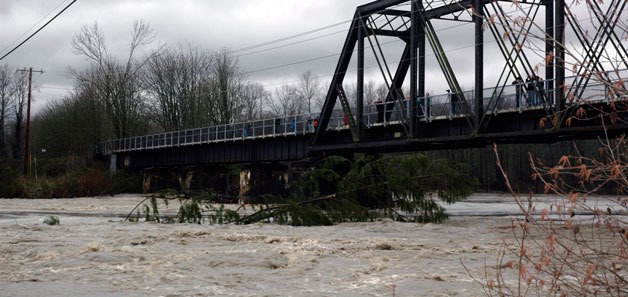
Arlington Heights residents who happened to be out of their neighborhood before noon on Dec. 12 found their way back home blocked when the rising river not only drowned the baseball and soccer fields of Twin Rivers Park east of Arlington, but also shut down the adjacent section of Highway 530 that afternoon. The children’s playground of Haller Park in downtown Arlington was likewise transformed into a giant puddle as the river rose to 21.16 feet shortly after 4 p.m., surpassing the historic high crest of 21.06 set there on Nov. 6, 2006.
Silvana firefighter and EMT Chris Meshke was visiting Haller Park at around 2:15 p.m. that day with his family, catching his breath after a work day that had begun the day before.
“We were putting sandbags down yesterday and making sure everybody who lives down by the river got out of their houses,” Meshke said Dec. 12. “We’ve been evacuating people all the way to Oso and Darrington all morning with hovercrafts.”
Although Meshke also works as a driver for Budweiser, he expected he would call in to his shift that evening to continue his emergency response work.
“I saw a Mini Cooper go through water that sprayed out higher than the car,” Meshke said. “You can’t just plow on through like that if you don’t know whether the roads beyond are wiped out.”
Arlington City Council member Chris Raezer had taken his camera equipment onto the Centennial Trail Bridge that afternoon to shoot photos of the floodwaters.
“It seems like it was higher a couple of years ago,” Raezer said at around 2:30 p.m., before the record from four years ago was matched at 3:54 p.m. “I’m amazed that there’s this much debris left behind from that last flood, though. You see the size of some of these trees and you wonder where they came from. Watching them go by is a pretty popular spectator sport,” he laughed.
Raezer was joined by a number of fellow Arlington residents, including Michele Rietz and Morgan Meehan, on the Centennial Trail Bridge which afforded veteran flood watchers from the area a vantage point they hadn’t had on previous years’ floods.
“It happens every year,” Rietz said at around 2:45 p.m. “We’ve got a nicer view of it from up on this new bridge. I like seeing all the big trees”
“It seems like the water rose much faster this year,” said Meehan, who’d waded through three-foot-deep waters to get to his parents’ cabin in Oso. “It’s still fun to watch.”
Arlington Fire Department Deputy Chief Tom Cooper explained that fire department personnel had been monitoring the situation since 5:30 a.m., but described the city of Arlington itself as relatively fortunate.
“Once we made sure we’d gotten folks out of low-lying areas, we haven’t had much in our own area,” Cooper said at around 3 p.m. “Oso and Darrington have been hammered, but Arlington hasn’t gotten hit with any real problems.”
At the same time, Cooper expressed concerns about the possible impact of flooding on the Arlington Food Bank, which is located in Haller Park, and estimated that the levy had washed over by about 100 yards.
“Don’t drive through floodwaters,” Cooper said. “Don’t even try it. Just wait.”
Emma Larson didn’t need to be told this advice twice, even as she found herself stranded outside of her home. Larson lives on Dike Road, and when she tried to drive back to her house at around 3:15 p.m., she found that floodwaters had washed over the road.
“All my dogs are still in the house, but they’ll be fine,” said Larson, who hoped to stay with family friends in town. “The last time it was like this, it flooded all around the house, but it didn’t come up the steps.”
City of Arlington Natural Resource Manager Bill Blake and Capital Projects Manager Paul Ellis were touring the area, and Blake offered assurances about the state of the levy.
“Floodwaters have gone over the top of the levy, but it’s not broken,” Blake said at around 3:30 p.m. “If we’d had more snow in the lower elevations, it could have been much worse, so we dodged a bullet there. We’re also lucky that it hasn’t rained that much in Arlington, so that hasn’t added to the floodwaters, which are mostly coming from the mountains and other higher elevations.”
Blake classified most of the trees that had been swept up by the flood as “old wood,” but acknowledged that erosion had allowed some younger trees to be felled as well. Regardless, he emphasized the absence of urban flooding in the city of Arlington itself.
In addition to Highway 530, Seventh Avenue NE was also closed, from 220th Street NE to the end of the road, due to water rising over the road at around noon on Dec. 12. Washington State Trooper Sean O’Connell likewise reported at around 4 p.m. that Pioneer Highway, west of Interstate 5, had been closed.
“People need to slow down during conditions like this,” O’Connell said. “I’ve actually seen people speeding through floodwaters. If you have to drive, plan ahead. Check which routes will be open. Use the Internet and the news, so that you don’t hit closed roads and have to take detours that add even more time to your trips.”
Snohomish County Executive Aaron Reardon has issued an emergency declaration to respond to flooding throughout the area. The Snohomish County Department of Emergency Management Call Center is open for residents to ask questions or report damages, and can be reached by calling 425-388-5088. Road flooding should be reported to the municipalities in which they occur, while flooding on county roads can be reported to the county’s Public Works Department by phone at 425-388-7500 or via e-mail at contact.pwrm@snoco.org.
Relevant flood information can be found by logging onto www.snoco.org and clicking “Flood Emergency Information.”